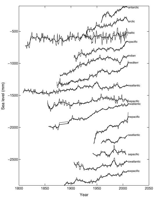
We use 1277 tide gauge records since 1807 to provide an improved global sea level reconstruction and analyse the evolution of sea level trend and acceleration. In particular we use new data from the polar regions and remote islands to improve data coverage and extend the reconstruction to 2009.
There is a good agreement between the rate of sea level rise (3.2 ± 0.4 mm/yr) calculated from satellite altimetry and the rate of 3.1 ± 0.6 mm/yr from tide gauge based reconstruction for the overlapping time period (1993–2009). The new reconstruction suggests a linear trend of 1.9 ± 0.3 mm/yr during the 20th century, with 1.8 ± 0.5 mm/yr since 1970. Regional linear trends for 14 ocean basins since 1970 show the fastest sea level rise for the Antarctica (4.1 ± 0.8 mm/yr) and Arctic (3.6 ± 0.3 mm/yr). Choice of GIA correction is critical in the trends for the local and regional sea levels, introducing up to 8 mm/yr uncertainties for individual tide gauge records, up to 2 mm/yr for regional curves and up to 0.3–0.6 mm/yr in global sea level reconstruction. We calculate an acceleration of 0.02 ± 0.01 mm·yr-2 in global sea level (1807–2009). In comparison the steric component of sea level shows an acceleration of 0.006 mm·yr− 2 and mass loss of glaciers accelerates at 0.003 mm·yr-2 over 200 year long time series.
citation: Jevrejeva, S., Moore, J. C., Grinsted, A., Matthews, A. P., & Spada, G. (2014). Trends and acceleration in global and regional sea levels since 1807. Global and Planetary Change, 113, 11-22. doi:10.1016/j.gloplacha.2013.12.004 pdf

